8:36
Mountains of North East India with Animation
Zeta Axis (UPSC-SSC)
Overview
This video explores the diverse mountain ranges of Northeast India, categorizing them into three main groups: the Himalayan system, the Purvanchal Himalayas, and the Shillong Plateau. It details the geological origins of these mountains, primarily driven by the collision of the Indian and Eurasian plates, and explains how the direction of these forces influenced their orientation. The summary then delves into specific mountain ranges within each group, highlighting their locations, associated tribes, major rivers, and significant national parks, offering a comprehensive geographical overview of this ecologically rich region.
How was this?
Save this permanently with flashcards, quizzes, and AI chat
Chapters
- Northeast India is characterized by mountainous terrain, with most states (except Assam) being predominantly mountainous.
- The region receives heavy rainfall, leading to dense forest cover on its mountains.
- The mountains are broadly classified into three groups: Himalayan system, Purvanchal Himalayas, and Shillong Plateau.
Understanding the broad classification helps to organize the complex geography of Northeast India and provides a framework for learning about its specific mountain ranges.
Assam is mentioned as an exception, being primarily a valley region, while other states like Arunachal Pradesh and Sikkim are largely mountainous.
- These mountains are part of the larger Himalayan system, formed by the collision of the Indian and Eurasian plates.
- The compressive forces acted from the south, resulting in an east-west orientation.
- Key ranges include the Dafla, Miri, Abore, and Mishing Hills, located in Arunachal Pradesh and bordering Assam.
- The Mishing Hills are notable for hosting parts of the Namdapha National Park and the Dibang Biosphere Reserve.
This section explains the origin and orientation of mountains directly influenced by the primary tectonic collision, setting the stage for understanding subsequent ranges.
The Dafla Hills are named after the Dafla tribes inhabiting the region, illustrating the cultural and geographical intersection.
- These mountains also resulted from the Indian-Eurasian plate collision, but with compressive forces acting from the east.
- This eastward force created mountain chains with a north-south orientation.
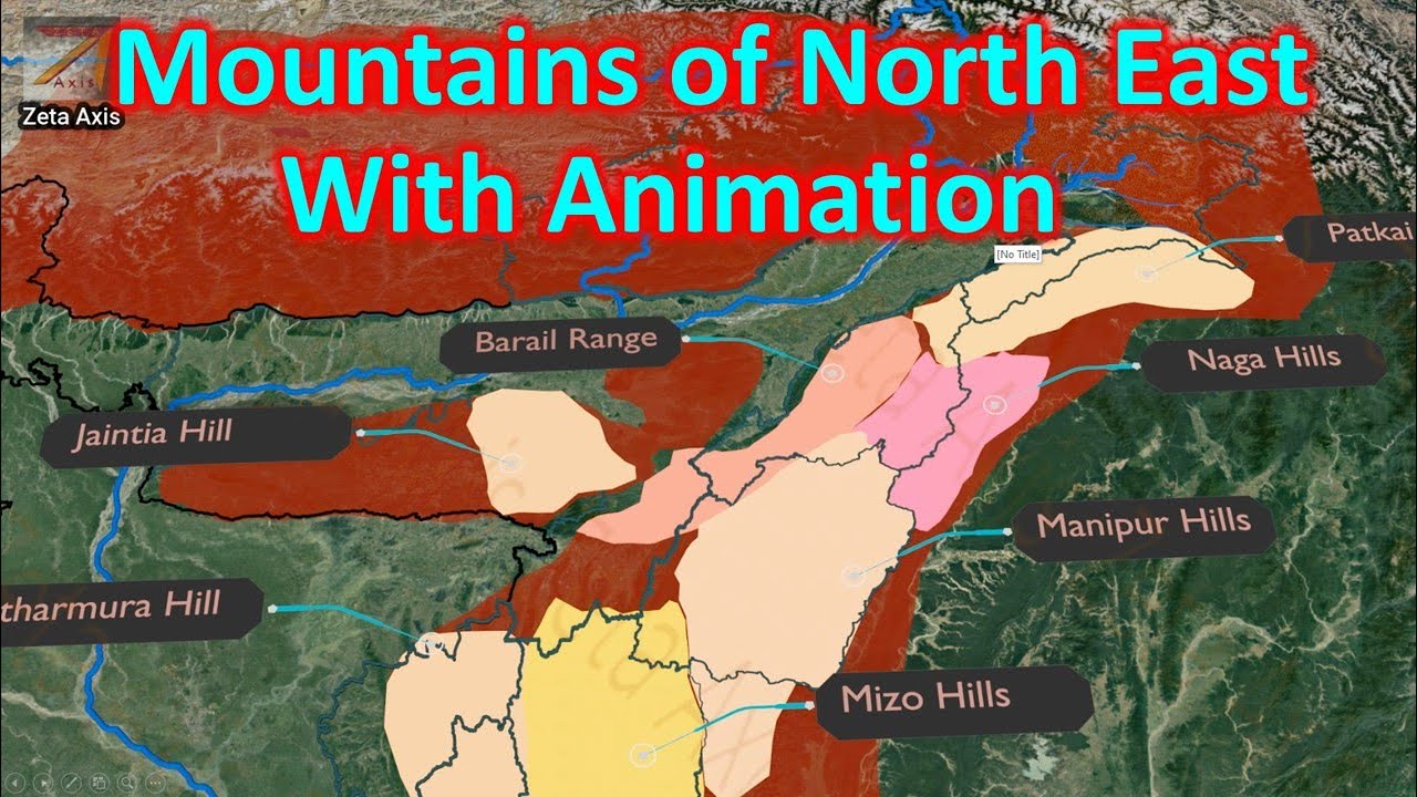
- Major ranges include the Pkahi, Naga, and Manipur Hills, extending through Nagaland, Manipur, Mizoram, Tripura, and parts of Assam.
- These ranges form the Indo-Myanmar border and are characterized by significant peaks like Mount Saramati and Mount Iso.
Understanding the Purvanchal Himalayas is crucial as they represent a distinct geological formation and orientation compared to the main Himalayan ranges, influencing biodiversity and regional geography.
Mount Saramati, the highest peak in the Naga Hills, is located on the India-Myanmar border, highlighting the trans-national nature of these ranges.
- South of the Manipur Hills lie the Mizo Hills (also known as Lushai Hills), an extension of the Pkahi range.
- These hills are known for their thick bamboo forests and feature peaks like Phawngpui (Blue Mountains).
- The Tripura Hills, with a north-south orientation, are located in Tripura and host unique wildlife in their national parks.
These southern extensions of the Purvanchal Himalayas showcase unique ecosystems and geological features, including significant biodiversity hotspots.
The Phawngpui National Park is located around the highest peak of the Mizo Hills, the Blue Mountains, named for their distinctive color.
- The Shillong Plateau, including the Garo, Khasi, and Jaintia Hills in Meghalaya and Assam, is an extension of the Peninsular Plateau.
- These mountains were formed by faulting during the plate collision and are known for extremely high rainfall.
- The Garo Hills are the westernmost part, while the Jaintia Hills are the easternmost.
- The region is characterized by tropical forests and significant peaks like Shillong Peak.
This plateau represents a geological anomaly, being an extension of the ancient Indian landmass rather than a direct product of Himalayan orogeny, and is famous for its extreme rainfall.
The Garo Hills are recognized as one of the wettest places on Earth due to monsoon winds interacting with the landscape.
- The Shillong Plateau extends eastward into the Karbi Anglong Plateau in Assam.
- The Karbi Anglong Plateau includes the Mikir Hills and the Rengma Hills.
- The Mikir Hills are bordered by the Brahmaputra plains and contain peaks like Dumpep.
- The region's mountains are closely associated with major river valleys like the Brahmaputra and Suma (Barak).
This section connects the plateau region to the major river systems and plains of Northeast India, illustrating the interplay between topography and hydrology.
Kaziranga National Park is situated north of the Mikir Hills, highlighting the proximity of wildlife reserves to these elevated regions.
Key takeaways
- The mountains of Northeast India are geologically diverse, formed by both Himalayan orogeny and the uplift of ancient peninsular blocks.
- The orientation of mountain ranges (east-west vs. north-south) is a direct result of the direction of tectonic forces during plate collisions.
- Many mountain ranges are named after indigenous tribes that inhabit them, reflecting a deep cultural connection to the land.
- Northeast India's mountains are critical habitats for numerous species, evidenced by the numerous national parks and biosphere reserves located within them.
- The region's topography significantly influences its climate, particularly its exceptionally high rainfall, especially in areas like the Shillong Plateau.
- Geographical features like mountains and plateaus play a crucial role in shaping river systems and river valleys in the region.
Key terms
Himalayan Mountain SystemPurvanchal HimalayasShillong PlateauIndian PlateEurasian PlateTectonic CollisionNorth-South OrientationEast-West OrientationBiosphere ReserveNational Park
Test your understanding
- How did the direction of compressive forces during the Indian and Eurasian plate collision influence the orientation of the Himalayan system versus the Purvanchal Himalayas?
- What is the geological significance of the Shillong Plateau compared to the Himalayan and Purvanchal ranges?
- Explain the relationship between the topography of Northeast India and its high rainfall patterns.
- How do the names of mountain ranges, such as the Dafla Hills, reflect the cultural landscape of Northeast India?
- Why are national parks and biosphere reserves particularly important in the mountainous regions of Northeast India?